Imagery Services

Imagery the way it should be: seamlessly visualized , intelligently optimized, effortlessly enabled, and expertly managed.

What are Imagery Services?

Shift cached layers to the cloud, decouple storage from compute, and let your Enterprise fly

Managed Imagery Processing

Tired of the complexity and high costs of imagery cache processing? Our Managed Imagery Processing is designed to save you money and hassle. We focus entirely on the size of the dataset you need to cache—the most accurate way to determine what's needed—so you only pay for what you use.

Lightning-Fast Turnaround

Our dynamic scaling and optimized processes mean faster results without the headaches.


Cost-Effective Scaling

We scale our resources based on your Servable Cache Size, which means we charge you based on that size. It's a fair, transparent, and highly efficient way to manage your costs.


Web Services & Tile Layers

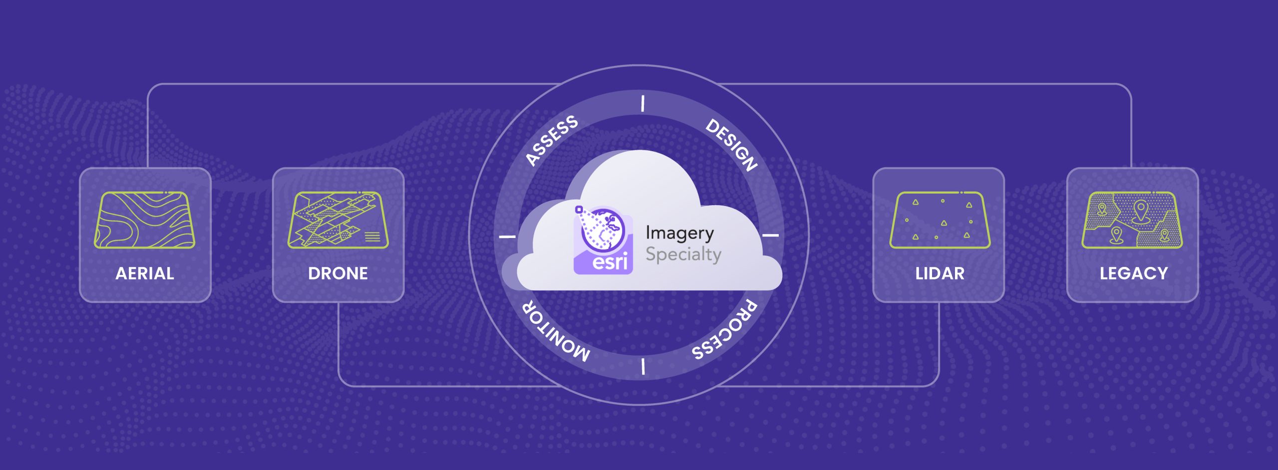
Whether you need Web Services (Map Image or Imagery services—especially popular in the AEC Sector) or Web Tile Layers (Raster, Vector, Elevation, or 3D Scene Layers), we have the expertise to process and deliver your data efficiently.


Schedule Your Caching Jobs

Need a layer or cache updated daily or on a regular schedule? We partner with you to ensure the layer is published, optimized, highly performant, and available exactly when and where you need it.


Imagery Backlog Migration: We Handle the Heavy Lifting

Need to migrate a massive imagery backlog? We ensure an efficient cloud transfer via AWS Snowball, Azure Storage Explorer, or a simple upload depending on how much imagery data you need to move. Once your data is in your chosen cloud storage, our Managed Imagery Processing Service takes over. We identify your data needs and publish optimized imagery web layers, guaranteeing a smooth, cost-effective, and complete migration.

Imagery Assessment: Always Free to Start!

Ready to see how we can help? Every client journey begins with a Free Imagery Assessment. We'll evaluate your needs and then guide you to the best solution, whether that's our Managed Imagery Processing or one of our full Imagery Processing Solutions + Support packages. No commitment, just smart advice to get you started!

Imagery Services

The New Standard for Imagery: Visualized, Optimized, Enabled, Managed.

Imagery is one of the most valuable GIS assets an organization possesses — but when it’s unmanaged, unindexed, or stored across disparate repositories, its value is trapped. Our Imagery Services organize, catalog, process, publish, and serve your imagery at scale so that teams across your enterprise can discover, analyze, and share it with confidence.

Whether you’re working with high-resolution aerials, drone collections, LiDAR derivatives, or decades of legacy raster data, we transform your datasets into reliable, accessible assets — ready for cloud delivery, web visualization, and analytic workflows.

Why Utilize our Imagery Services?

Accessible, Optimized, Shared, Enabled and Yes…Managed! Organizations that invest in imagery management are empowering teams to do more with less friction:

Faster Delivery

Pre-generated caches and raster tile layers improve display performance and reduce server load

Scalability

Designed to support enterprise, statewide, and global footprints without performance degradation.

Cloud-Native Integration

Hosted cloud caches registered with enterprise portals streamline distributed access across apps and devices.

Better Analytics

Clean, indexed datasets accelerate raster analysis and machine learning workflows.

Centralized Access

One searchable source of truth eliminates redundant storage and outdated copies.

How We Work With You

Assess & Plan

Understand your current imagery estate, usage patterns, and performance goals.

Design & Configure

Define storage architecture, tiling schemes, cache levels, and service types.

Process & Publish

Convert and publish imagery into scalable services — from tile caches to hosted raster layers.

Monitor & Optimize

Track performance, refine cache strategies, and ensure services stay responsive as your datasets grow.

Ready to Unlock Your Imagery’s Potential?

Modern GIS workflows demand imagery that’s accessible, performant, and useful. Let us help you organize, optimize, and serve your imagery so teams can focus on what matters — generating insight, not wrestling with data. With the Esri Imagery Specialty and our ArcGIS Cloud Services Specialty, our team of experts will help you unlock the value of your imagery by designing, deploying, and managing imagery solutions that augment your GIS capabilities. If you want to modernize your ArcGIS Enterprise, implement ArcGIS Image Servicer, lower your cloud storage costs, or explore GeoAI, we’re ready to help you build what comes next.

How It Works

Advanced Cloud Caching for ArcGIS: Deliver faster maps, reduce server load, and cut cloud storage costs

Advanced Cloud Caching for ArcGIS: Deliver faster maps, reduce server load, and cut cloud storage costs

Modern GIS depends on cached layers for speed and performance—but not all caches are created equal.

Cloud-Ready Imagery for Distributed Teams: How to Consolidate, Cache, and Collaborate

Cloud-Ready Imagery for Distributed Teams: How to Consolidate, Cache, and Collaborate

If your imagery feels slow, fragile, or trapped on a single machine, you’re not alone.